


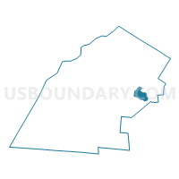
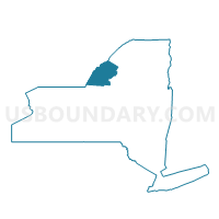
Voting District 060003, Jefferson County, New York
About
Outline

Summary
| Unique Area Identifier | 627511 |
| Name | Voting District 060003 |
| County | Jefferson County |
| State | New York |
| Area (square miles) | 15.69 |
| Land Area (square miles) | 15.19 |
| Water Area (square miles) | 0.51 |
| % of Land Area | 96.76 |
| % of Water Area | 3.24 |
| Latitude of the Internal Point | 44.01682870 |
| Longtitude of the Internal Point | -75.70016620 |
Maps

Graphs
Select a template below for downloading or customizing gragh for Voting District 060003, Jefferson County, New York


Neighbors
Neighoring Voting District (by Name) Neighboring Voting District on the Map
- Voting District 060001, Jefferson County, NY
- Voting District 060002, Jefferson County, NY
- Voting District 110006 110009, Jefferson County, NY
- Voting District 110007 110008, Jefferson County, NY
- Voting District 180002, Jefferson County, NY
- Voting District 220002, Jefferson County, NY
- Voting District 220003, Jefferson County, NY
- Voting District 220004, Jefferson County, NY
- Voting District 220005, Jefferson County, NY
Top 10 Neighboring County Subdivision (by Population) Neighboring County Subdivision on the Map
- Le Ray town, Jefferson County, NY (21,782)
- Wilna town, Jefferson County, NY (6,427)
- Champion town, Jefferson County, NY (4,494)
- Rutland town, Jefferson County, NY (3,060)
Top 10 Neighboring Place (by Population) Neighboring Place on the Map
- Fort Drum CDP, NY (12,955)
- Carthage village, NY (3,747)
- West Carthage village, NY (2,012)
- Great Bend CDP, NY (843)
- Deferiet village, NY (294)
- Herrings village, NY (90)
Top 10 Neighboring Unified School District (by Population) Neighboring Unified School District on the Map
Top 10 Neighboring State Legislative District Lower Chamber (by Population) Neighboring State Legislative District Lower Chamber on the Map
Top 10 Neighboring State Legislative District Upper Chamber (by Population) Neighboring State Legislative District Upper Chamber on the Map
Top 10 Neighboring 111th Congressional District (by Population) Neighboring 111th Congressional District on the Map
Top 10 Neighboring Census Tract (by Population) Neighboring Census Tract on the Map
- Census Tract 608.04, Jefferson County, NY (7,895)
- Census Tract 609, Jefferson County, NY (6,169)
- Census Tract 611, Jefferson County, NY (5,776)
- Census Tract 610, Jefferson County, NY (3,685)
Top 10 Neighboring 5-Digit ZIP Code Tabulation Area (by Population) Neighboring 5-Digit ZIP Code Tabulation Area on the Map
- 13619, NY (10,901)
- 13602, NY (3,881)
- 13612, NY (2,852)
- 13638, NY (378)
- 13628, NY (220)
- 13643, NY (19)